DATA RE THE WESTERN WALL IN JERUSALEM
~ PAGE 2 ~
|
Other pages on this general subject are here: Pages 1, 3, 4, & 5. On the platform above the Western Wall, sits today what to me, at least, is the most beautiful building that I have ever seen - The Dome of the Rock. While I assemble some data about the building, & search for quality images, I will provide here three maps, one very ancient, one over 100 years old & the final map relatively new. The first two "maps" come courtesy of the University of Southern Maine, which has on its splendid site an amazing number of ancient maps from all around the world. Do visit their Jerusalem Exhibit by clicking here. But like all of my pages, this page will expand as I introduce additional data that interests me & may well interest you also. But a reminder as always. This page and the site to which the above link takes you, are designed for a 1024 x 768 screen setting. The University of Southern Maine website describes the map which forms the first of the images below in some considerable detail (modified in the presentation below). I must add that the complete print, a woodcut of 27.4 x 128.4 cm in size, was published in 1486 & appears here courtesy of the Osher Collection. I have presented above just the central portion of the print, that which depicts the city of Jerusalem. The complete print, available here presents a panoramic depiction of the region extending from Damascus & Tripolis in the north to the Red Sea & Alexandria in the south.
And next is a "Bird's eye view of Jerusalem", published ca. 1900 in West Roxbury, Mass., courtesy of the University of Southern Maine & the Kyram Collection. A coloured lithograph, 43.7 x 67.4 cm in size, it depicts, I am advised, the traditional view of Jerusalem from the Mount of Olives, with Jesus weeping over the city. It was produced by an American Syro-Maronite church belonging to a Roman Catholic sect based in Lebanon, & was apparently designed as a souvenir for pilgrims. Christian, Islamic, & Jewish holy sites are shown. For this page, I slightly rotated the image in order to make it as close to horizontal as I could, so by all means see the original image here.
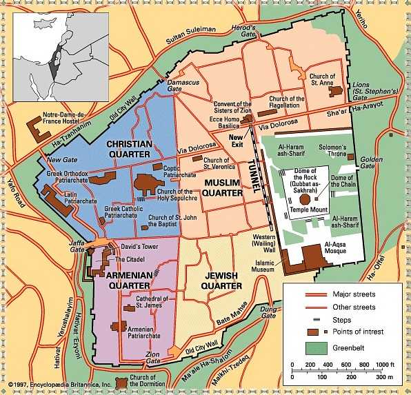
And last on this page, so far at least, is a map of Jerusalem today. Now you would think that a map of similar simplicity & content could be readily found on the WWW. Not so! I have found maps of every conceivable variety but none as good as the map that follows which is by Encyclopedia Brittanica Inc. & dated 1997. In view of its date, it probably is already "out of date". But it does show the tunnel under the Western Wall & I am glad to be able to show you that. I hope that "Encyclopedia Brittanica" will not object to its presentation here. If they do, I will gladly remove it.
to Western Wall Pages 1, 3, 4, 5 ~ Special Pages Index. |